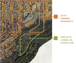
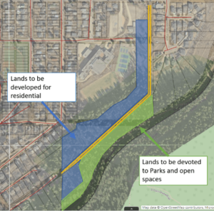
The City of Nelson has reached a land-swapping agreement with Sunburst Acres Inc. to acquire a continuous stretch of forest extending from the Great Northern Rail Trail into Nelson.
The City plans to use the land to create parkland and establish a public road through the currently private lands at the end of Trevor Street.
A media release from the City states the area is currently one of the highest wildfire risks in the city due to its steep slopes, dense coniferous tree cover, and potential risk from ember showers.
Now, the City can apply for grants to fund fire mitigation efforts and create a new park that borders the rail trail.
“Council deliberated over a number of factors over the past year related to the land swap – including housing availability, ecosystem stewardship, and active transportation connections – and decided to proceed due to the increased safety benefits it will provide for our community,” said Mayor Janice Morrison.
In exchange for this land, Sunburst will construct an emergency egress road to serve the 114 residences in the Trevor and Selby Street area, which currently only has one access point. The land swap areas are of equal value.

The new road will connect Trevor Street to Davies Street, with the first half paved and the remainder built to a gravel standard.
At present, the City does not meet National Fire Protection Association standards for emergency egress in the Trevor Street area, as too many homes rely on a single access route. The new road will address this issue now that the land is no longer privately owned.

The new roadway will meet national egress standards, enhance wildfire protection measures, and improve traffic flow during evacuations.
Additionally, Sunburst will subdivide about 20 R1 (low-density residential) lots in phases while constructing the roadway. The gravel portion of the road will be paved as future lots are developed, as required by the City.
The City states the project aligns with several community plans, including the Official Community Plan’s focus on neighbourhood connectivity, the Active Transportation Plan’s vision for linking Fairview and Uphill, and the Community Wildfire Resiliency Plan.
Be the first to know! Don’t miss out on breaking news and daily updates in your area. Sign up to MyNelsonNow News Alerts.


